Current Investigations


The Search for Stathern Hall, Leicestershire
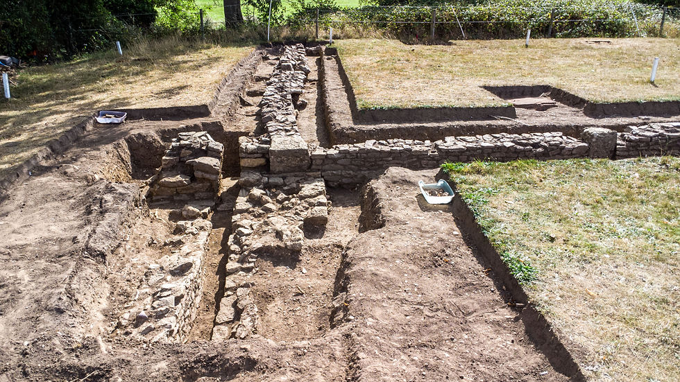
Stathern was the home of the King Killer, Colonel Francis Hacker. It was also where one of the most significant documents in British history was kept, from the execution of Charles I on 30 January 1649, through to the trial of Francis Hacker on 15 October 1660. It is known as the Death Warrant. To our knowledge, there are no surviving maps or written accounts that can tell us where the hall once stood. Previous attempts to find the hall have been unsuccesful but, undeterred, The Field Detectives, with the support of The Leicestershire and Rutland Wildlife Trust and the lovely people of Stathern, carried out an excavation on the Coombs Meadow nature reserve in the hope that it would lead us to Colonel Francis Hacker’s front door.
A copy of the 2026 Dig Report can be found here
A copy of the Field Detectives' 2023 report can be downloaded here
The Dalliwell Stile Investigation is now complete, and the report can be downloaded here
The Pillbox Field survey report can be downloaded here
Catherine's book - 'A Further Account of the Hacker Family' is available at:

"I think I've got something in my field."
Hoveringham, Nottinghamshire
Is this the home of the de Hoveringham and Goushill families, who were the lords of the manor c.12th-14th century, or is this part of the broader Thurgarton Priory estate, or is it a bit of both? Just to add another layer of mystery to the investigation, somewhere on the landscape is the site of a celebrated Georgian spa.
The images featured here were taken in September 2025 by The Field Detectives’ drone, thanks to the kind permission of the RAF. As you can see, the emerging historic landscape is slowly beginning to tell the story - This is Nottinghamshire’s Pompeii.


Hall Close Investigation Drone Flight - September 2025
Click Image to Enlarge
The Sutton Roadside Mystery
With the kind offer of permission from the landowner and family, The Field Detectives, and the Granby cum Sutton History Group came together to see if they could solve the timeline mystery of a site where a windmill once stood.
The geophysical survey was conducted over two days; Wednesday 7th and Thursday 8th August 2024 and the results were amazing. As you can see from the two images, there is a moat, a possible bridge into the site and some potential stone buildings.
Granby cum Sutton history group have produced their research document following the success of the geophysical survey and a full copy of the report can be downloaded here
Aileen and Peter’s geophysical survey report can be downloaded here
Another exciting collaboration


Click images to enlarge


All Trackways Lead to the Field Chapel
Cropwell Butler, Nottinghamshire
The ancient Cotgrave to Saxondale trackway investigation focuses on three periods of history that could potentially help us unlock a growing list of uncertainties relating to our historic landscape study findings at both Cropwell Butler and Owthorpe. The trackways that appear to originate from the medieval chapel of St Nicholas at Cropwell Butler (demolished) have produced early medieval and Romano British artefacts.
The purpose of the investigation is to carry out a methodical field survey on the fields adjacent to the line of the ancient Cotgrave to Saxondale trackway, the Cropwell Butler parish boundary, and related landscape trackways.
The question is, do they all have a landscape connection to the Cropwell Butler field chapel?
Maps showing location of the field chapel
Click to enlarge
The Spellow Hill Invesigation
On Sunday 2nd March 2025, The Field Detectives concluded the Far Hill field survey. It was the first survey of nine fields in the Spellow Farm historic landscape study. Our interrogation of the field in search of clues that could shed light on the history of Spellow Hill, and its potential use as an administrative meeting place by our Anglo-Saxon/Scandinavian ancestors yielded very little supporting evidence. There is a long way to go, and in historic landscape study terms, we have only just begun. Once the neighbouring fields have been surveyed we will be able to join their stories together as one historic landscape jigsaw. Only then will we be in a position to see the bigger picture, which should provide us with a much more informed understanding of Spellow Hill.

Langar, Nottinghamshire
On Saturday, 5 May 2018, the Field Detectives commenced the first phase of their historic landscape investigation on the Langar block of fields, situated to the southwest of present-day Langar Hall.
The three field surveys presented an opportunity to focus on the search for evidence to support a Romano-British trackway running from the Goadby Marwood ironstone industrial site to the Margidunum settlement near Bingham, on the Fosse Way. It would also allow us to examine the medieval landscape to see if any remaining artefacts could be associated with the nearby St Ethelburga pilgrimage site and to learn more about the history of the former Langar Hall grounds.
With the end of the historic landscape investigation in sight, there have been many wonderful discoveries that have emerged from the fields over the last six years, and they will all be included in the final historic landscape study report.
The learning from the surveys would not have been made possible if it were not for the trust, encouragement and support of Samworth Farms.

The Resurrection Rumble - the first time the bell has rung in over 150 years!